For those in professional photography and video production, drones are one of those inventions that sometimes make you wonder how the job was ever done without them. Officially known to the FAA in Part 107 of its regulations as small Unmanned Aircraft Systems (UAS), the machines have become a meeting place in the sky for GPS, topographical mapping, RF remote control, cutting-edge batteries, Real-Time Kinematic (RTK) technology and miniaturized cameras. All of this makes the FAA’s scramble to regulate ultralights and kitplanes of the 1980s appear to have been easy. Here we round up some of the latest models that blend these capabilities with serious work and creative fun.
 A familiar and respected face in the highly competitive world of drones is the AEE Aviation Technology Mach 6. With a 13lb. lifting capacity and a seven-mile range, this machine is collapsible for easy pack-up and transport. Its incredibly versatile range of payloads includes controllable cameras, spotlights for night operation, bullhorns, infrared imagers, and many more very useful devices, some of which can be carried simultaneously. The hexacopter is designed to continue operating with one engine out and includes dual antenna Real-Time Kinematic (RTK) mapping for extreme accuracy in surveys and ground object location. Millimeter radar provides collision avoidance while this drone buzzes the sky for up to 50 minutes. It can carry a dual payload thermal camera with High-Resolution RGB and 3-axis gimbal. The EHOOK enables 13.2lb. loading and a remote drop system.
 Ladies and gentlemen, start your phones because the new Autel Robotics EVO Lite is equipped with a 4-axis gimbal that allows it to shoot vertical videos for showing and editing in the cellphone format. Its 50MP camera is equipped with a 1/1.28-inch CMOS sensor that uses the RYYB color filter array design and autofocus to be especially effective in showing vivid natural scenery and fast-moving objects. Going beyond the traditional Autel Orange, this model is available in Arctic White and Deep Space Gray. With features such as dynamic tracking and Autel SkyLink transmission, the drone can steadily follow subjects in motion and clearly transmit those 2.7K/30FPS images interference-free for up to 7.4 miles. These videos can be narrated live from any smartphone and verbal editing notes can be recorded. The ultra-wide angle obstacle avoidance cameras face forward with a 150-degree field of view.
 The DJI Inspire 3 has plenty of speed without sacrificing anything on the photographic and video capability. This machine can go almost 18mph straight up and dive at over 22mph with a maximum horizontal speed near 60mph. Crafted smoothly into the airframe, the FPV (First Person View) camera, visual sensors, positioning antennas, and 1TB storage card slot are much heavier in function than in form. The RTK positioning system is accurate to less than two centimeters and all the drone’s capabilities are housed in a vehicle with a maximum takeoff weight of about nine pounds. The front and rear stacked ceramic antennas provide anti-magnetic interference capability, and a quick release makes it very easy to switch payloads. The vehicle can fly for up to 28 minutes on the 23.1V 4280mAh Li-ion battery. Flight-route and shot planning are done using the Waypoint Pro automated mapping tool.
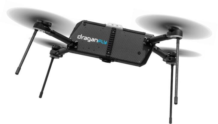 The most recent in a line of successful models, the Draganfly Apex can be configured for a wide range of assignments and easily reconfigured for different tasks. Its variants include the Apex Core and the Apex Ultra. These are capable of 20-minute flight time with a 6.6lb. payload and that time stretches to 32 minutes when carrying only 2.2lbs. Both models have FPV cameras, RTK compatibility, signal encryption, onboard computing, and flight automation. The Apex Core has a 5-mile transmission range while the Apex Ultra can send its signal 20 miles or more. The airframe folds into a space that is 45in. wide, 42in. long and 15in. high. These smart machines are compatible with a variety of Nvidia-embedded compute boards making them incredibly versatile tools. The picatinny mounting system holds payloads up to 5lbs. and the XT30 connector powers payloads from a dual battery system.
 When payload weight is the issue, the Drone Volt Hercules 20 can be the solution, bringing its 33lb. heavy lifting capability. Manual control and automated flight work seamlessly through the Drone Volt Control Application for operation of the drone and the camera. A cellphone can be connected to the bottom of the flight controller to display video and flight information such as flight time, battery level, altitude, flight mode, and more. A variety of payloads includes winch, net, spray tool, payload dropper, and the FLIR Duo Pro camera with its 4K RGB sensor and radiometric thermal sensor. The camera can be used for geo tagging and it has a picture-in-picture mode. All flight data are stored and can be recalled in an immediate report. The body and the carbon fiber frame and anodized aluminum fasteners make this vehicle a tough customer for wear and tear.
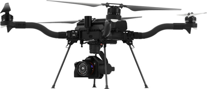 Touting advanced lift capability and quieter operation from it 21in. propellers, the FreeFly Astro makes 96 percent of its total area the relatively slow-turning props. The optical and infrared capabilities are impressive with its Sony LR1 camera which can be fitted for simultaneous photography, infrared sensing, and laser range finding. This versatile instrument can be fitted with 24mm, 35mm, 50mm, and 75mm lenses. The LR1 is among a variety of sensing payloads from different manufacturers. Precise camera and gimbal control is achieved with Astro’s Pilot Pro controller that attaches to a Samsung tablet with 8in. display and features redundant screens, real-time logging, error reporting, and a redundant kill switch. Flight modes include return to launch, altitude mode, position mode, and manual mode. Colored LEDs indicate drone is powered and flight ready, powered but not ready, low battery, and critical error.
 Tethered drones are limited in range but excel in power and flight time, capable of hovering in position for days or even weeks. The Hoverfly Sentry is a proven example of tethered drone capabilities, one of which is quick deployment of a high radio antenna. But that is not the whole story. This vehicle can carry an assortment of payloads including PTZ2 standard EO/IR camera and the NextVisiton Raptor long-range dual EO/ IR stabilized camera. Also onboard can be radios for instant network and relay creation. The drone’s automatic reel system maintains a 0.8lb tension to sustain its position relative to the ground station. It is also capable of multi-site control with Smart Command software by Hexagon. The payload capacity is 1.8lbs. and its maximum altitude is 200ft. If tether power fails, the vehicle also carries a backup battery for safe landing.
 Fast setup and takeoff make just one feature of the small Lumenier Litehawk sUAS but one of its more remarkable abilities is that of entering a building through an opening of less than 18 inches in diameter. While performing such a feat, the four propellers are protected by prop guards to allow the vehicle to bump into things and keep going. This one can carry up to 2lbs. of payload and, depending on the load, keep flying for up to 23 minutes. Its 16in. length also helps it to get into small spaces. There are three switchable flight modes including position hold, altitude hold, and stabilized mode. The foldable 3-blade propellers have the POPO (Pop-On Pop-Off) Quick Release that allows them to be changed in seconds with the push of a button. Capable of carrying a day or night camera, this American-made drone has a flight time of 8 minutes and 15 seconds.
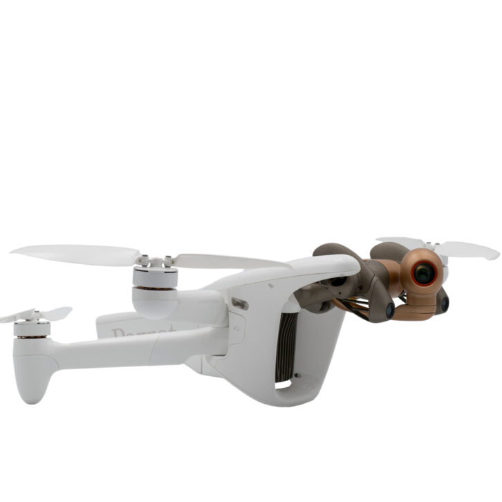 The Parrot Anafi Ai 4G robotic UAV, as the name implies, features 4G internet connectivity with worldwide compatibility and superior signal range. The onboard 48MP camera shoots 4K/60 video through a 6x zoom and the craft can perform autonomous photogrammetry while flying for up to 32 minutes. The system is powered with a 6800mAh 4.4V high-density Lithium Polymer battery that recharges on a USB-C port and drives the drone at up to 34mph in level flight. The Skycontroller 4 uses Wi-Fi 802.11a/b/g/n and 4G in the 2.4GHz-5GHz band. This sends mp4 video at 1080p and 4K UHD resolution. The JPEG and DNG (Digital NeGative RAW) still photography is accomplished with automatic framing with visual tracking with 6-axis stabilization. Ports include microSD and SIM card slots.
 Built tough and IP55-rated to handle a range of weather conditions, the Percepto Air Max can emerge from its protected Percepto Base and use its onboard module to fly in heavy rain, snow, dust, and high winds. If anything does go wrong, it is even equipped with an FAA-compliant parachute. The base is an industrial grade weatherproof drone docking station with an integrated weather station, and patented docking and charging mechanism. It carries 24MP RGB and radiometric thermal cameras and data captured by the Air Max is uploaded to AIM software, an AI-powered cloud platform delivering insights, reports, and alerts. In addition, the 21lb. drone can be fitted to perform optical gas imaging. The AI-powered flight management enables impressive versatility
 Rated IPX4 to be waterproof, dust-proof, and equipped with parallax cameras for object detection, the versatile quadcopter Prodrone PD4-XA1 is small enough to be easily carried in one hand. The retractable airframe and hot swap battery make the ground setup as speedy as its air performance. The craft is deployed and retracted by simple locking levers and folds to less than a foot wide. The 20x Sony module optical zoom camera is gimbal mounted with strong vibration protection and it can be switched to a DSLR for still photography. Even night searching is possible with an LED searchlight that is mounted to follow the camera’s view. Onboard capabilities include collision avoidance sensed by the forward stereo camera with drone control and video distribution via LTE. There is also a tethering option for long-duration local surveillance.
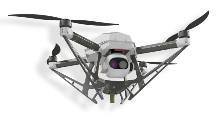
 The latest drone technologies are unified in the new Skydio X10D, an open, modular platform that can be operated with the Skydio X10D controller and the Flight Deck control app or it can be used with third-party controllers. This vehicle supports multiband radio and channel switching to deal with any radio interference. After a 40-second deployment, it can get up to 45mph in level flight and this Blue UAS-qualified machine is IP55-certified against water and dust. Its modular, high-resolution visual and radiometric thermal cameras allow a huge range of mission types using the VT300-Z or VT300-L which also carries a flashlight. These sensor modules offer a combination of six custom-designed navigation lenses and allow the system to build 2D maps and 3D models onboard, in real time.
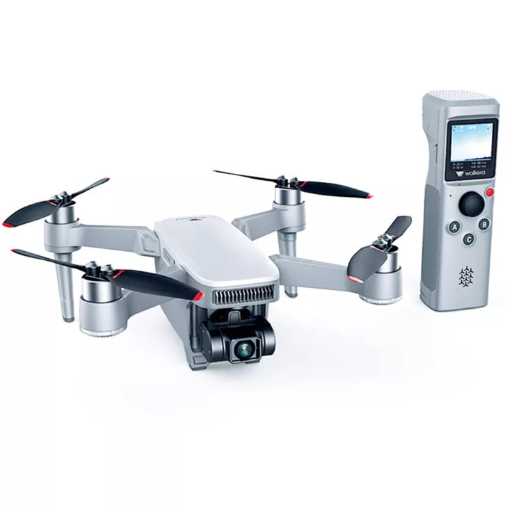 The new Walkera T210 was designed for tracking shots of moving vehicles in a variety of environments. Hand-launched and voice controlled, the craft can fly along in any position relative to the subject it is tracking. The drone can fly circles around a moving car or look straight down on the object it is tracking. Using 2.4G transmission, it can send video nearly two miles, rejecting RF interference. The T210 app turns a smartphone into a controller and aerial video display. The T210 is also capable of hovering to shoot time-lapse photography while the 3000mAh battery keeps it in the air for up to 31 minutes. The 4K H.264 encoding camera shoots through an 85-degree view, ultra-low distortion lens.
 One of the more interesting and innovative designs is the fixed wing WingtraOne Gen II large area surveying drone. This craft sits straight up on its back end, climbs straight up on its twin leading-edge propellers, and transitions to level, fixed-wing flight somewhat reminiscent of the Harrier Jump Jet or the old Convair XFY-1 Pogo Cold War V/STOL turboprop. The big orange WingraOne can fly as fast as 36mph for up to 59 minutes and use its full-frame 61MP camera for mapping with one centimeter accuracy in ideal conditions. The system uses the WingtraCloud mapping app to perform mapping, arrange projects, enable team collaboration, and sync flights. A tablet is included to enable video output and control. The WingraOne Gen II can carry a wide variety of camera payload modules to suit any surveying or mapping project.
 Capable of going far afield carrying plug and play payloads to precisely determined spots and back is the Yuneec H520E. This proven model has six motors and if any one of them fails, it can correct its guidance and stay in the air with just five running. For up to 28 minutes after takeoff and retracting its landing gear, this machine can fly with hot-swappable cameras and communicate from nearly two miles away. With the gear retracted, the camera can pan and tilt freely without obstructions. Data storage may be shared from the ST16S/E Ground Station or delivered directly in 4K/2K/HD video or 20MP stills shots and none of it is forwarded to external manufacturer servers. The Android-based controller has a 7in. integrated screen that allows the user to plan a flight and execute with a single button push.
 Its props and motors are protected in a flying cage so the Zero Zero Robotics HOVERAir X1 PRO can survive minor obstacle bumps and scrapes if necessary and fly right on. The craft is so small it can be carried in a coat pocket, taken out, and hand-launched in seconds. Available in black or white, it can hover, follow an intelligent flight path, and orbit a moving ground object. Weighing in at less than four and a half ounces including the battery, the HOVERAir X1 is a flying camera that can speed up to 15mph and get smooth, dynamic follow shots within 5ft. of its target. The HOVERAir App allows the user to set flight altitude and distance along with camera resolution. The storage capacity is 32GB and flight time for this mini machine is 11 minutes.